
COLORADO TRAIL
The Colorado Trail is a 500 miles (800 km) hiking trail from Denver to Durango in the USA.

MOVIE ENTIRE TRAIL

MOVIE TRAILER

PHOTOS


Sunrise from copper mountain with hiker

Hiker on the trail in Weminuche Wilderness

The old Wild West town Silverton
Sunrise from copper mountain with hiker
Trail description
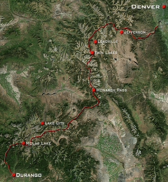
This is a high elevation trail where you will spend most of your time between 10 to 13.000 feet,
(3 to 4000 meters). You start at Waterton Canyon, south of Denver. The first couple of days is about climbing and getting used to the altitude. Then you pass through the ski areas between Copper Mountain and Aspen.
At Twin Lakes the trail splits so you have to make a choice how to get through the Collegiate mountains. You can take the lower more accesible route or go high up and take the west route, which is rough, steep and very remote. If you are fit, we certainly recommend the west trail.
After the Collegiates, the trails come together again and the mountains become more friendly, But not for long.
Before you know it you head straight into the spectacular San Juan mountain range.
And by the time you reach Durango you have climbed a total of 27 km, that’s 90.000 feet.
Because of the altitude, this trail is only recommended in summer. But the end of summer brings the monsoon rains. Which start in the early afternoon. So pick your date not too late, otherwise you might get rain or snowed upon.
The trail also takes you close to some really beautifull old mining towns. Like Breckenridge, Leadville, Lake City and Silverton. You have to make stops to resupply anyway so make sure not to miss those old Wild West towns.
TRAIL INFO
United States, Colorado.
The trail goes through the spectacular Rocky Mountains. You will see high peaks, lakes, forests, and maybe an occasional bear, moose, dear or bever.
There are six wilderness areas you go through. Expect awesome views, old Wild West towns and beautifull nature.
Check out the links below for more information about the trail.
Great CT resources
Here are some resources that can help you in your preperation.
Official website.
A paid GPS app for your phone. It has all the maps of all the sections plus a whole lot of other stuff too. Like the West Collegiate alternative route.
A simple to use website where you can get detailed maps and trail info.